6.4 Air Masses
6.4 Air Masses
An air mass is a large body of air with similar temperature and humidity characteristics. The area over which an air mass originates is called a source region. The longer the air mass stays over its source region, the more likely it will acquire the properties of that surface. Air masses exhibit the properties of their source regions within one or two weeks of residing there. They form within the boundary layer, or that portion of the atmosphere interacting with the Earth’s surface, and under a high pressure. The high pressure assists in keeping the air from migrating out of the source region.
Air masses are classified using two letters. The first letter is lower case and designates the moisture content of the air:
- c (continental) forms over land and is dry
- m (maritime) forms over water and is moist
The second letter is upper case and designates the temperature of the air:
- A (Arctic or Antarctic) is very cold
- P (Polar) is cold but not as cold as the Arctic
- T (Tropical) is warm to hot
- E (Equatorial) is hot
The temperature characteristic corresponds to the latitude over which the air mass formed.
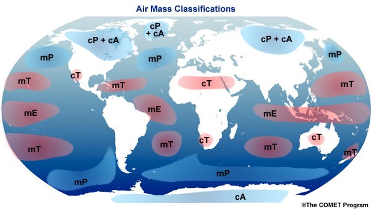
This first diagram illustrates the source regions and their associated air masses over North America and the direction they tend to move. The second map depicts all the source regions around the globe.
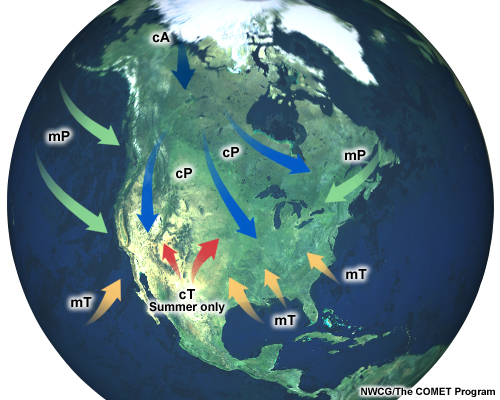
Whenever air masses start to move their characteristics begin to modify. A continental polar (cP) moving south over North America will begin to warm. If a maritime polar or tropical (mP or mT) air mass moves inland, it will start to dry out.
Notice that no air masses form over land in the midlatitudes. Air masses collide and mix in the midlatitudes, which discourages air from residing unperturbed for a week or two. Air masses form over a source region only when the air can remain in that location.
6.4.1 Characteristics of cA, cP and mP
The continental polar (cP) air masses form over the large, high latitude land masses such as Canada and Siberia. Notice no cP air masses exist in the Southern Hemisphere. The Southern Hemisphere has no high latitude land masses.
These regions have short days and low Sun angles in the winter. These areas lose more energy than they received. The cold temperatures make the air extremely dry. This cold air resides near the surface with a strong inversion above it, which makes for stable conditions. During the summer, cP conditions are not as extreme and the air masses tend not to migrate from where they form.
The continental arctic (cA) air masses are more extreme than the cP air masses, and originate over the poles. They have much colder air with a much stronger inversion above it for extremely stable conditions. Arctic air masses tend to be shallower in depth than polar ones.
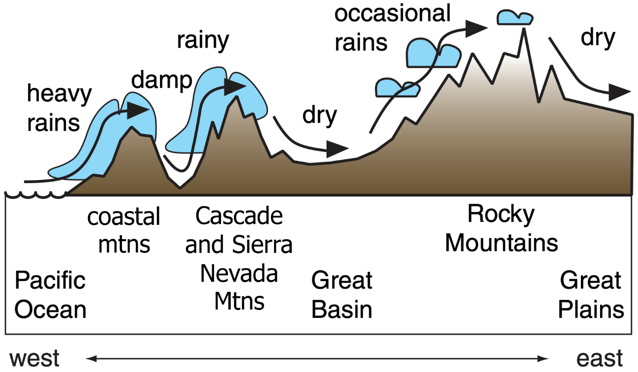
The maritime polar (mP) air masses contain moisture, since they originate over the higher latitude oceans. The temperatures are slightly moderated from the cP air masses, because they formed over water. These moisture laden air masses tend to drop precipitation when they move inland. This figure illustrates the precipitation that occurs over the mountain ranges of western North America associated with an mP air mass moving over land.
The eastern portion of North America has a similar situation with mP air masses. These air masses are a key component in the Nor’easters which form off the New England coast.
6.4.2 Characteristics of cT, mT and mE
The continental tropical (cT) air masses develop under the subtropical high near 30o latitude during the summer months.
These air masses form due to the intense surface heating of the desert landscape. The hot air created near the surface rises to great heights on its own and is thus extremely unstable. These source regions lack moisture, so hot and sunny conditions can prevail for many days. Once moisture enters the area, usually from an mT air mass, intense thunderstorms can occur.
Maritime tropical (mT) and maritime equatorial (mE) air masses develop over tropical waters and are warm, hot, and humid. Tropical air masses on the equator are referred to as maritime equatorial (mE) but are essentially the same as mT. The difference between the two is the location where they form. Since these air masses contain warm to hot and moist air near the surface, they can be unstable. Hurricanes form in these air masses.
During the winter when mT air masses migrate north over land, they invariably collide with cP air masses moving south. This clash between the two air masses creates significant weather in the midlatitudes. This interaction of air masses is examined in more detail in the next section on fronts.
Video: Mod 6.4.2 Air mass classification and characteristics (5:35 min.)
This video describes air mass classification and the characteristics of air masses. The movement of air masses across North America is presented along with precipitation from an mP air mass in the Pacific Northwest.
References:
NH-airmasses.jpg and air-masses.jpg – From The COMET Program and has their copyright embedded.
mP-precipitation-editted.png – “Airmasses” by Roland Stull, LibreTexts is licensed under CC BY-NC-SA and found at https://geo.libretexts.org/@api/deki/files/6886/Screen_Shot_2020-03-06_at_8.25.28_PM.png Modified by changing text Olympic Mtns to coastal mtns, removed Puget Sound, added Sierra Nevada Mtns, and removed the numbers used in the sample application.
