5.4 Measuring and Tracking Surface Water
Measuring and Tracking Surface Water
Streamflow is the amount of water flowing in a channel. Measuring streamflow is important for multiple reasons:
- To determine how much water is available to supply population and agricultural needs.
- To ensure interstate agreements, compacts and court decrees are met.
- To design transportation facilities (roads, bridges, culverts) and water treatment plants for normal and extreme variations in streamflow.
- To manage power generation facilities in an efficient and optimal manner.
- To plan for floods and flood warning systems.
Measuring streamflow involves three steps:
- Measure the stage or gage height of the water surface at a location on the river.
- Obtain periodic discharge measurements at this location. Discharge is the streamflow volume passing a location over a given time period.
- Create a stage-discharge relationship from the data obtained in steps 1 and 2.
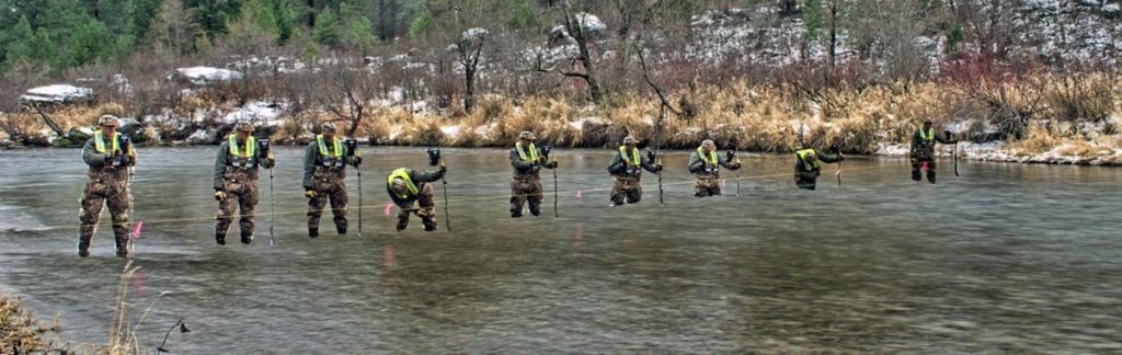
This photograph shows U.S. Geological Survey employees obtaining discharge data (step 2) for a river in Montana. This approach works well for a shallow river with light flow that allows a person to stand in the water. For deeper rivers or higher flows, this approach will not work. The remainder of this section examines the details associated with each of these three steps, and how the resulting streamflow data is displayed.
Module 5.4.1
Stream Stage (Gage) Measurement
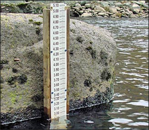
Stage, sometimes called gage height, can be measured using a variety of methods (step 1). The most basic method is to place a measuring board in the river. While easy to implement, this method is not the most accurate as the board decays. Additionally, getting a manual reading of the river height can be hazardous at night or during a flood.
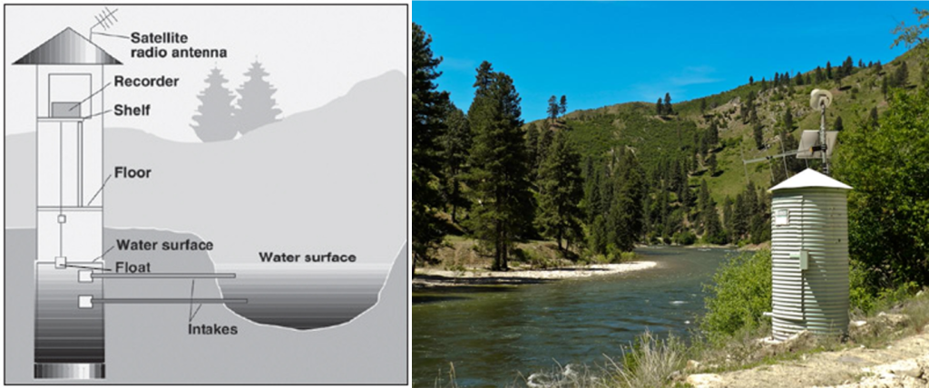
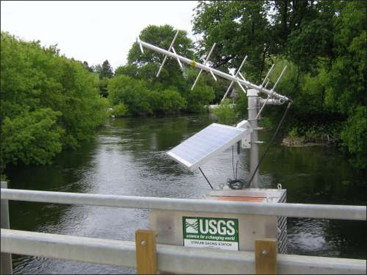
Another common approach is with a stilling well in the riverbank or attached to a bridge pier. Water from the river enters and leaves the stilling well through underwater pipes allowing the water surface in the stilling well to be at the same elevation as the water surface in the river. The stage is then measured inside the stilling well. The measured stage value is stored in an electronic data recorder on a regular interval, usually every 15 minutes.
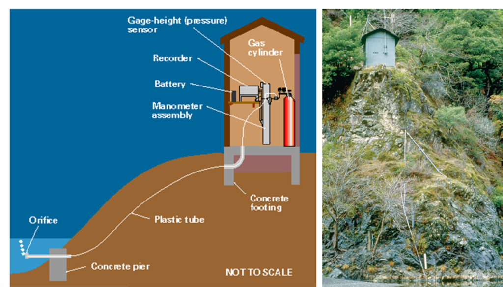
At some stream gage sites, a stilling well is not feasible or is not cost effective to install. As an alternative, stage can be determined by measuring the pressure required to maintain a small flow of gas through a tube that is bubbled out at a fixed location under the water. The measured pressure is directly related to the height of water over the tube outlet in the stream. As the depth of water above the tube outlet increases, more pressure is required to push the gas bubbles through the tube. This type of stream gage is called a pressure transducer.
A fourth approach to measuring water level are noncontact sensors. These devices use acoustic or light waves that reflect off the water below. They are generally mounted to bridges above the water channel. These types of stream gages have fewer moving parts which simplifies long-term maintenance. Noncontact sensor gages are widely used in southern Arizona.
Stage at a stream gage must be measured with respect to a constant reference elevation, known as a datum. Sometimes stream gage structures are damaged by floods or can settle over time. To maintain accuracy, the elevations of gage structures are routinely surveyed relative to permanent elevation benchmarks.
Although stage is valuable information, most people are interested in streamflow or discharge. However, it is not practical for a stream gage to continuously measure discharge. Fortunately, there is a strong relation between river stage and discharge, and a continuous record of river discharge can be determined from the continuous record of stage. Determining discharge from stage requires defining the stage-discharge relationship by measuring discharge over a wide range of river stages. The next section examines how to determine river discharge.
Module 5.4.2
Discharge Measurements
Discharge is the volume of water moving down a stream or river per unit of time, commonly expressed in cubic feet per second. In general, river discharge (step 2) is computed by multiplying the area of water in a channel cross section by the average velocity of the water in that cross section:

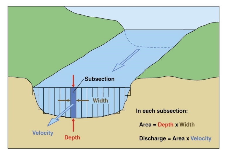
The most common method used for measuring velocity is with a current meter. The current meter is used to measure water velocity at predetermined points (subsections) along a marked line, suspended cableway, or bridge across a river. The depth of the water is also measured at each point. These velocity and depth measurements are used to compute the total volume of water flowing past the line during a specific interval of time. This next photo shows a current meter.
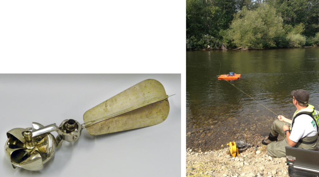
Another method to measure the discharge is with an acoustic Doppler current profiler. The Doppler Effect is the phenomenon we experience when passed by a car or train that is sounding its horn. As the car or train passes, the sound of the horn seems to drop in frequency. The profiler is mounted on a small watercraft with its acoustic beams directed into the water. The profiler is then guided across the water surface to obtain measurements of velocity and depth. This photo shows an acoustic profiler in use on the Boise River in Idaho.
With stage height and discharge measurements taken, the stage-discharge relationship (step 3) can be created. The next section describes these state-discharge relationships.
Module 5.4.3
Rating Table (Curve)
Stream gages continuously measure stage (step 1). This continuous record of stage is translated to river discharge by applying a stage-discharge relationship (also called rating). A rating table, or rating curve, contains the relationship between stream gage height and discharge. The difference between a rating table and a rating curve is the first one is a table of data, the second one is a graph of the data. Both a rating table and a rating curve contain the same information just in a different format.
Rating tables are developed for stream gages by physically measuring the flow of the river with a mechanical current meter or acoustic profiler at a wide range of river heights (step 2). For each measurement of discharge there is a corresponding measurement of stage (step 3). Special effort is made to measure extremely high and low stages and flows because these measurements occur less frequently. The stage-discharge relation depends upon the shape, size, slope, and roughness of the channel at the stream gage location and is different for every gage. Unfortunately, river channels are continuously changing through erosion, deposition of soil materials, vegetation and other debris. This situation causes a need to continually take new discharge measurements, which ensures the most accurate information is available.
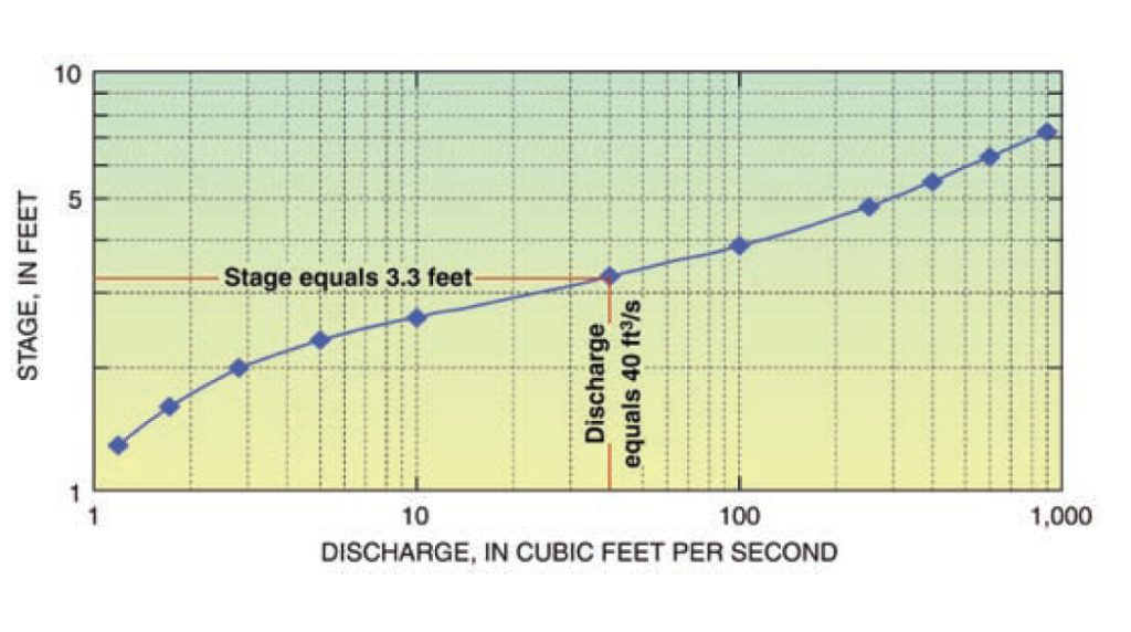
Stage heights are continuously available. With a rating curve, discharge is continuously available too. In this example, a stage height of 3.3 feet equals a discharge of 40 cfs. River flow is expressed as cubic feet per second (cfs) in the United States. A cubic foot is about the size of a basketball. Hence, 40 cfs visually would have 40 basketballs passing this location on the river every second.
Much like weather data, real-time river data is available in the United States. This web site has the current river flows for the entire U.S. The surface runoff from precipitation is being tracked just like the actual precipitation itself.
Module 5.4.4
Hydrographs
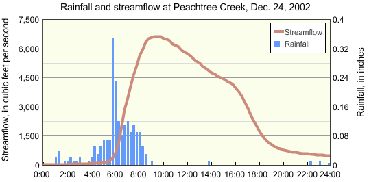
A hydrograph is a graph that shows changes in discharge or river stage over time. This figure shows a hydrograph (solid line) along with the precipitation (bar graphs) that caused the creek to rise.
A hydrograph always has time on the x-axis. This hydrograph has discharge on the left side of the y-axis, and precipitation amounts on the right side. The precipitation amounts allows us to see how fast the river flow changes when precipitation occurs. The maximum precipitation occurred at about 6:00 am. The highest flow in the creek occurred around 9:30 am. Over three hours lapsed between the time of the highest rainfall rate and the peak in streamflow. A peak discharge after a precipitation event is called a crest. If several high precipitation amounts occur, then several crests in the river may also occur. Every river has different characteristics for how fast it reacts to precipitation and how fast a crest flows downstream.
The next hydrograph relates stage height, rather than discharge, to time.
This hydrograph is for the Santa Cruz River at the Cortaro Farms bridge in Arizona. In early October 2014, the remnants of Hurricane Norbert provided precipitation across the Santa Cruz Basin. The water level rose about 3 feet due to this precipitation. Additionally, two crests are shown which are likely due to two episodes of heavier precipitation.
Another aspect to notice about this hydrograph is the red line at about 6.3 feet. This red line indicates essentially the bottom of the river channel. Most people assume a stage or gage height starts at the bottom of the channel and measures up. That assumption is frequently incorrect, because the bottom of the channel is not designated as zero. Never assume the bottom of the channel starts at zero for any gage location. In this example, the Santa Cruz River normally has about a foot to a foot and a half water in it at this location, not 7 feet.
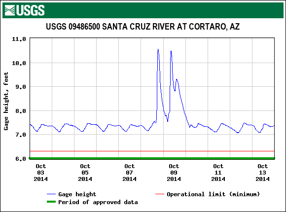
The last aspect to notice on this hydrograph is the diurnal variation in the flow. Much like temperatures in weather, the water level goes down to minimum and up to some maximum during a day. These changes occur naturally based on evaporation, groundwater flows, snow melting into the channel or other local conditions.
Video: Measuring Streamflow and Hydrographs (6:16 min)
This short video reviews the three steps associated with measuring streamflow.
References:
banner-measuring-streamflow.jpg – Public domain photo from the USGS at https://www.usgs.gov/media/images/how-streamflow-measured
Information on measuring streamflow is from the USGS and is found at https://www.usgs.gov/special-topic/water-science-school/science/how-streamflow-measured?qt-science_center_objects=0#qt-science_center_objects.
Illustrations, photos and large portions of the text are from the USGS at https://www.usgs.gov/special-topic/water-science-school/science/how-streamflow-measured?qt-science_center_objects=0#qt-science_center_objects
Illustrations, photos and portions of the text are from the USGS at https://www.usgs.gov/special-topic/water-science-school/science/how-streamflow-measured?qt-science_center_objects=0#qt-science_center_objects
Illustrations, photos and portions of the text are from the USGS at https://www.usgs.gov/special-topic/water-science-school/science/how-streamflow-measured?qt-science_center_objects=0#qt-science_center_objects
hydrograph-with-precipitation.png – In the public domain from the USGS and is found at https://www.usgs.gov/special-topic/water-science-school/science/how-much-water-flows-during-a-storm?qt-science_center_objects=0#qt-science_center_objects
Santa-Cruz-hydrograph.gif – From the USGS at https://nwis.waterdata.usgs.gov/az/nwis/uv/?cb_00060=on&cb_00065=on&format=gif_default&site_no=09486500&period=&begin_date=2014-10-03&end_date=2014-10-13
