5.1 Cloud Types
Clouds
Clouds form from the same mechanisms that lift air and cause cooling. These four mechanisms were examined in the last module. The types of clouds present in a region provide visual clues as to the state and stability of the atmosphere. This short video reviews some of these mechanisms with respect to cloud formation.
Cloud Appearances or Shapes
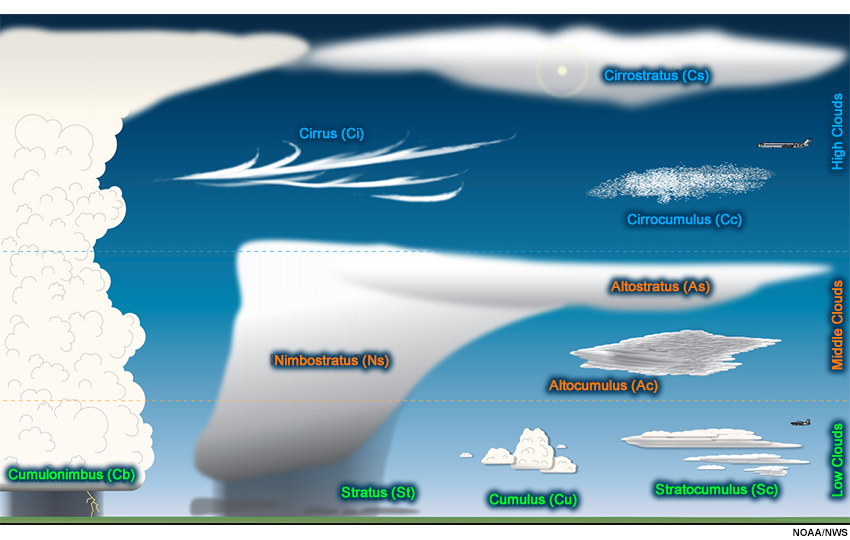
Two characteristics define all the types of clouds (1) appearance or shape and (2) height. A cloud appearance or shape falls into one of four categories: (1) cirro-form, (2) strato-form, (3) nimbo-form, and (4) cumulo-form.
 Cirro-form clouds are composed of ice crystals and are whitish and hair-like. The Latin word ‘cirro’ means curl of hair. They are the high, wispy clouds to first appear in advance of a storm system and are usually the remnants of a storm after it decayed.
 Nimbo-form clouds have precipitation originating from them. The Latin word ‘nimbus’ means rain. Nimbus is added to the other cloud forms when precipitation is occurring such as nimbostratus (a layer cloud with rain) or cumulonimbus (a vertically developed cloud with rain).
 Cumulo-form clouds have vertical development, usually originating from thermals and convective heating. Cumulus clouds start out looking like fluffy cotton balls and can rise to great heights. They are dense in appearance and have sharp outlines during development.
Cloud Heights
Cloud heights fall into one of four categories: (1) high, (2) middle, (3) low, and (4) vertically developed or covering multiple heights. The physical height of a cloud is determined by the depth of the troposphere at that location. Remember a constant pressure surface is higher at the warmer equator than at the cooler poles. These temperature differences cause the troposphere to be deeper in the tropics and shallower at higher latitudes. The troposphere is divided into three heights for clouds based on their total depth as is illustrated here.
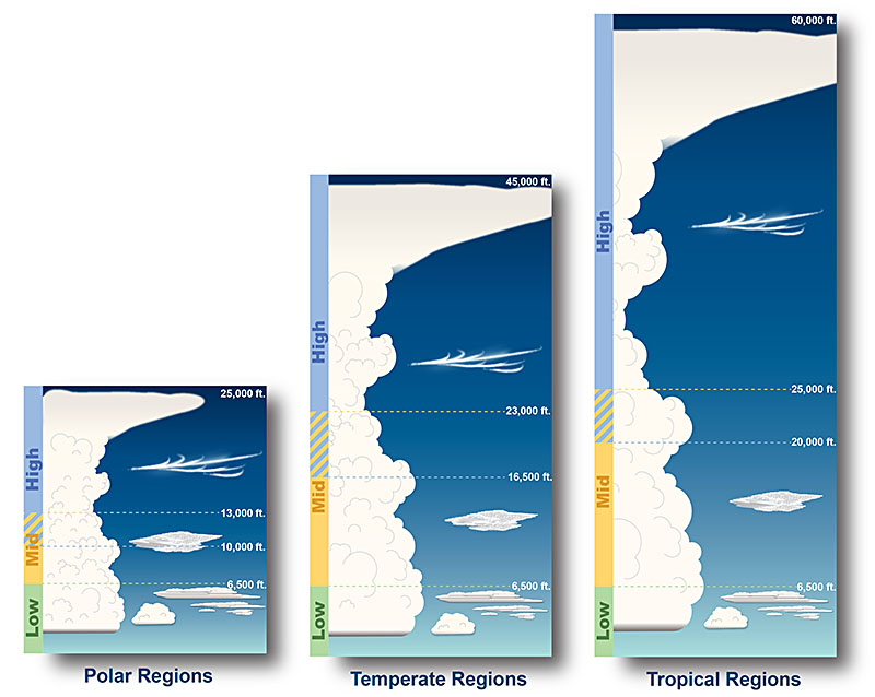
The actual latitudes of these regions vary seasonally. However, the polar region is generally from 60° latitude to the pole. The temperate region is from 30° to 60°, and the tropical from 30° to the equator. This table contains the cloud height categories based on latitude. Notice that all latitudes and regions have the same heights for low clouds.
| Level | Polar Regions | Temperate Regions | Tropical Regions |
|---|---|---|---|
| High Clouds | 10,000-25,000 feet | 16,500-45,000 feet | 20,000-60,000 feet |
| Mid Clouds | 6,500-13,000 feet | 6,500-23,000 feet | 6,500-25,000 feet |
| Low Clouds | Surface-6,500 feet | Surface-6,500 feet | Surface-6,500 feet |
The remainder of this submodule examines these types of clouds and their associated appearance/shape and height. The next graphic shows all the types of clouds discussed in this section.
5.1.1 High Clouds
Cirrus, cirrocumulus, and cirrostratus are high level clouds. They are typically thin and white in appearance, but can appear in a magnificent array of colors when the sun is low on the horizon.
Cirrus are detached clouds in the form of white, delicate filaments, mostly white patches or narrow bands. They may have a fibrous (hair-like) or silky sheen appearance.
Cirrus clouds are always composed of ice crystals, and their transparent character depends upon the degree of separation of the crystals. As a rule, when these clouds cross the Sun, they barely diminish its brightness. When they are exceptionally thick, they may mask the Sun’s light and blot out its contour.
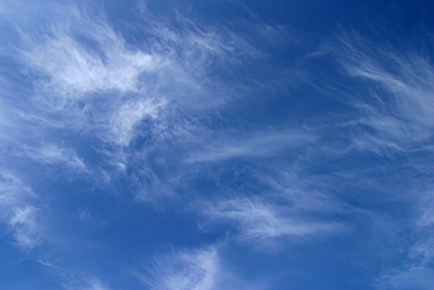
Before sunrise and after sunset, cirrus is often colored bright yellow or red. These clouds are lit up long before other clouds and fade out much later; some time after sunset they become gray. At all hours of the day, cirrus near the horizon (a long distance away) often have a yellowish color.
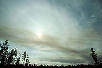
Cirrostratus is a transparent, whitish cloud with a fibrous (hair-like) or smooth appearance. A sheet of cirrostratus is large and usually covers the entire sky at some point. During the day, when the sun is sufficiently high above the horizon, the sheet is never thick enough to prevent shadows of objects on the ground.
A milky thin stratus (a low cloud) can be distinguished from a cirrostratus with a similar appearance by the halo which the Sun or the moon creates. A halo is a bright ring around the Sun or moon, and will be covered in more detail in another module. Cirrostratus is able to create a halo because it is composed of ice crystals. A lower stratus cloud is composed of water droplets and cannot create a halo. A faint halo is seen in this picture of cirrostratus.
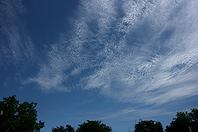
Cirrocumulus is a thin, white patch or layer of clouds composed of very small elements in the form of grains or ripples. Cirrocumulus may be composed of supercooled water droplets, as well as small ice crystals, or a mixture of both.
In general, cirrocumulus represents a degraded state of cirrus and cirrostratus. Cirrocumulus may be attached to cirrus or cirrostratus and has some of the characteristics associated with these other ice crystal clouds.
5.1.4 Vertically Developed Clouds
Two vertically developed clouds are cumulus and cumulonimbus. Both of these cloud types start out as a low cloud and can build up through higher levels. Cumulo-form clouds tend to be diurnal in nature in that they develop and build from the morning into the afternoon and dissipate in the evening.
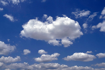
Cumulus clouds are detached, generally dense clouds with sharp outlines. They develop vertically in the form of rising mounds, domes or towers with bulging upper parts often resembling a cauliflower. The sunlit parts of these clouds are mostly brilliant white, while their bases are relatively dark and horizontal.
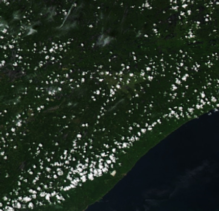
On a satellite image, cumulus appear to be small cotton balls evenly spaced apart. This satellite image depicts cumulus clouds near the Great Lakes.
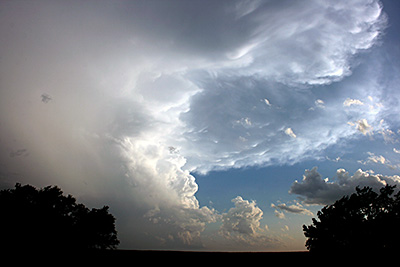
A cumulonimbus cloud is commonly called a thunderstorm and is a heavy, dense cloud in the form of a mountain or huge tower. The upper portion is usually smooth, fibrous or striated and frequently flattens into the shape of an anvil or large plume.
The base of this cloud is often very dark. When precipitation is present, low ragged clouds can occur that may or may not be attached to the primary cloud body. Thunderstorms can produce heavy precipitation, hail, strong winds and tornadoes. This photograph is a mature cumulonimbus cloud.
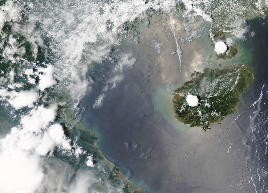
Developing thunderstorms start out on satellite imagery as a large round cloud. Once the storm encounters the tropopause, it spreads outward with cirrus clouds. This satellite image shows the development of a thunderstorm in the South China Sea. The cumulonimbus builds during the day and decays after sunset. Notice the shadows on the east side of these storms prior to sunset. Vertically developed storms have noticeable shadows when the sun angle is low. More than one thunderstorm can be seen in these satellite images.
5.1.5 Fog
Fog consists of water droplets suspended in the air that are in contact with the ground. The difference between fog and a cloud is the cloud is suspended above the ground. Fog restricts visibility and occurs when the temperature and dew point are close to equaling each other. Fog rarely forms when the temperature and dew point are separated by more than about 2oC or 4oF.
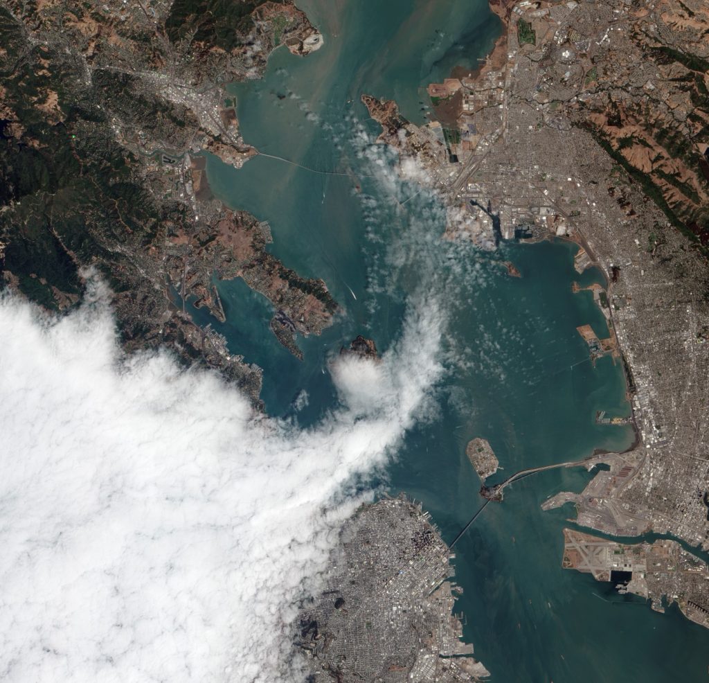
Two common types of fog are (1) advection and (2) radiation fog. Advection fog occurs when moist air moves over a cold surface. The air cools to the dewpoint which allows for condensation to occur. Advection fog is common near seas and oceans as warm moist air moves northward over cooler water. This satellite image from NASA shows advection fog moving into the San Francisco Bay area.
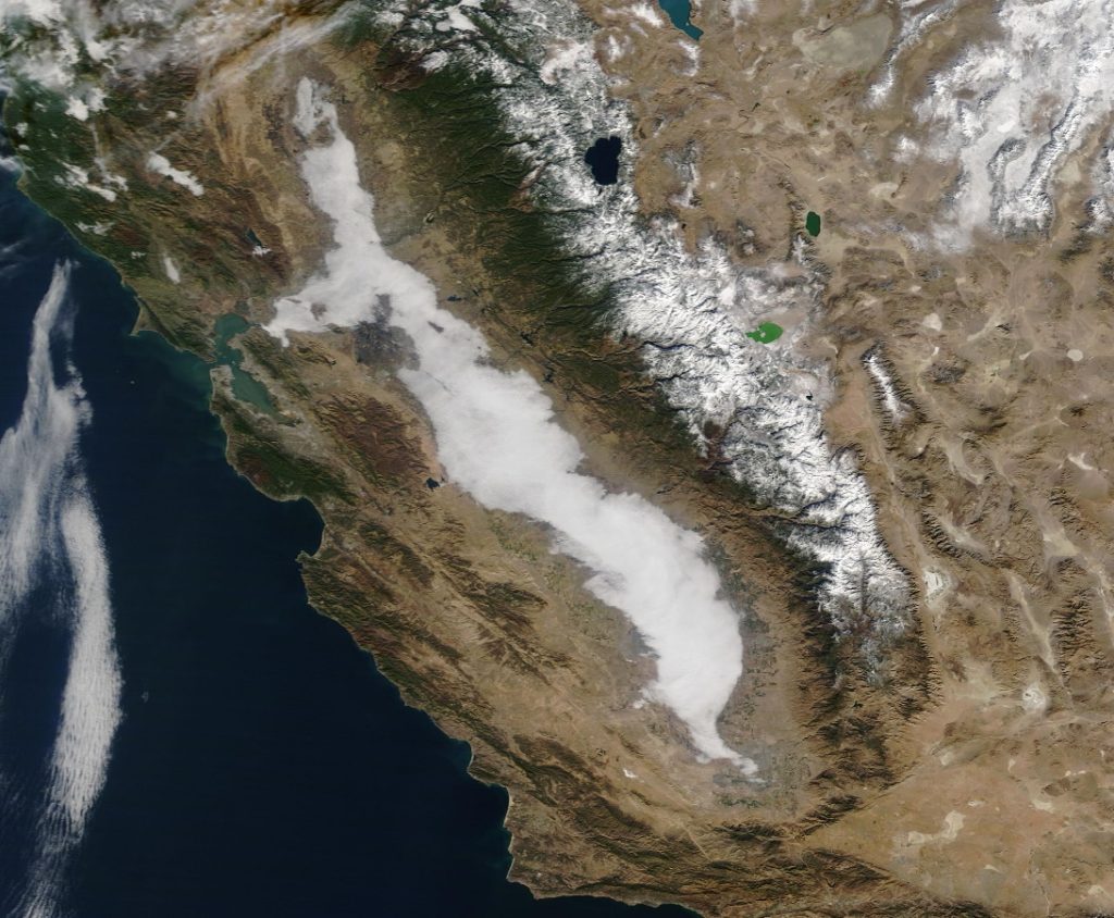
Radiation fog occurs at night when the ground cools the lower layer of air to the dewpoint. This type of fog needs a moist layer of air near the ground, which can occur when the ground is damp. Hence if it rains during the day and skies clear at night, radiation fog can form. During the night, the ground cools which in turn cools the air closest to the ground. When the Sun comes up in the morning, radiation fog tends to thin and dissipate from the outer edges first. Radiation fog is generally what occurs in southern Arizona. This satellite image from NASA shows radiation fog in the Central Valley of California on December 20, 2020.
