4.5 Atmosphere Stability
So far in this unit, we have covered a lot of information on understanding atmospheric moisture, saturation, condensation, and the mechanisms within the atmosphere causing these conditions. However, once an air parcel has been lifted and the lifting mechanism stops, what happens? Does the air continue to rise? Does the air stop at the point where it was lifted? Does the air sink back down to where it originated? All these questions are related to atmospheric stability. Stability is related to buoyancy and answers these questions. This section covers the types of stability which are possible in the atmosphere.
4.5.1 Buoyancy and stability
The reason for looking at air parcels in the previous section is to help determine the stability of the atmosphere. As a parcel starts to rise, its density determines whether it is less dense (warmer) than the surrounding air or denser (cooler). Warmer air rises, similar to a hot air balloon. Colder air sinks because it is heavier than the surrounding air. These density differences determine the buoyancy of the parcel. Buoyancy is the tendency of an air parcel to rise. Gravity is the force that pulls air parcels downward.
Examining the possible combinations of buoyancy and gravity in the atmosphere defines four possible categories of stability:
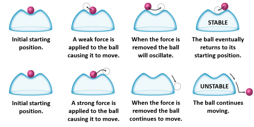
- Absolutely stable – The air parcel is denser (colder) than the atmosphere and returns to its initial altitude before it was lifted. Gravity wins! The pink ball in this diagram represent an air parcel with absolute stability.

- Absolutely unstable – The air parcel is less dense (warmer) than the atmosphere and continues to rise. Buoyancy wins! This diagram illustrates absolute instability

- Neutral stability – The air parcel once lifted is the same temperature as the surrounding atmosphere and remains at that altitude. Gravity and buoyancy are equal and the contest is a tie. Neutral stability rarely happens in the atmosphere since air is constantly in motion.

- Conditional instability – The atmosphere is unstable if certain conditions are met, otherwise it is stable. Conditional stability is a common state of the atmosphere. These diagrams illustrate this “maybe, maybe not” situation.
4.5.2Unstable Conditions
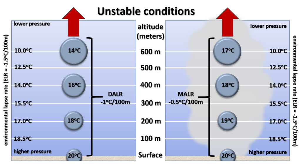
Unstable conditions are when the air parcel continues rising on its own with no need for a lifting mechanism. The air parcel is warmer than the environment, and once nudged upward continues rising. This diagram illustrates unstable conditions.
The left side of this diagram is the dry adiabatic lapse rate without condensation.
The right side is for a moist environment with condensation. The environmental lapse rate in this example is -1.5oC / 100m, which is a very cold atmosphere. The air parcel is warmer at all altitudes as it rises. Warm air rises on its own as is depicted. The latent heat associated with condensation causes the parcel to gain even more heat as it rises on the right side.
Thermodynamic diagrams allow for a quick analysis of stability conditions. So far, we have looked at the vertical (temperature) and horizontal (pressure) lines on a Stüve diagram. The other curved and slanted lines on the diagram are dry and moist adiabats. These adiabatic lines enable a person to determine what happens when a parcel is lifted. The quantity of adiabatic lines allows the lifting of an air parcel from any starting temperature or altitude.
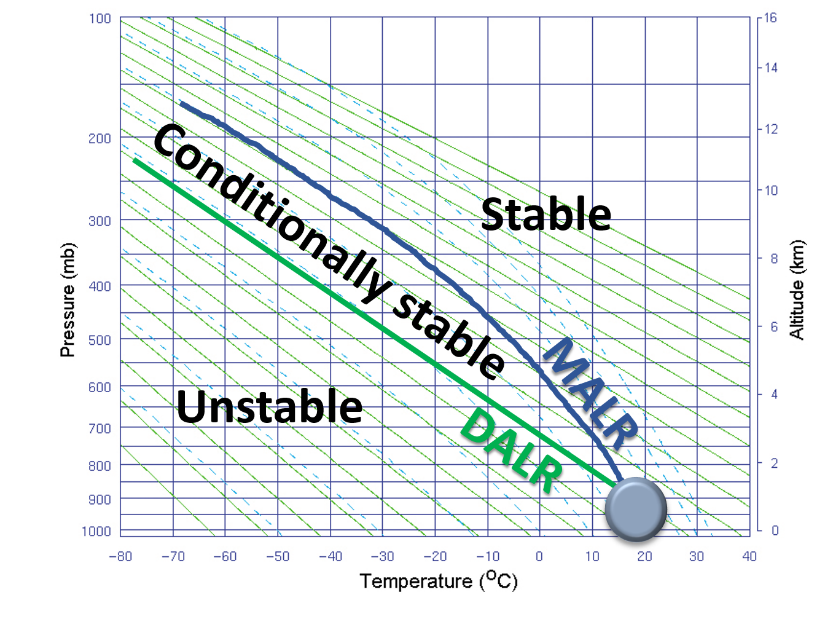
The DALR and MALR lines are labeled on this diagram and are associated with a specific air parcel as indicated. Additionally, the regions of unstable, conditionally stable, and stable conditions are labeled. When the temperature data from a weather balloon is plotted on a Stüve diagram, it will fall into one of these regions. Unstable conditions occur when the environmental lapse rate (ELR) is colder than the DALR. The first illustration in this section has the ELR (-1.5oC / 100m) decreasing faster than the DALR (-1.0oC / 100m).
While theoretically possible, unstable conditions in the atmosphere are rarely observed. Why? Physically what would be happening in unstable conditions is the bottom layer of the atmosphere is rising to the top. The atmosphere would essentially be flipping itself upside down. However, prior to these conditions happening the atmosphere is already adjusting itself to remain stable. The closest to unstable conditions observed is when the ELR equals the DALR, which can occur in the desert Southwest during intense surface heating in the summer.
Video: Mod 4.5.2 Unstable conditions (5:29 min.)
This short video examines unstable conditions.
4.5.3 Stable Conditions
Stable conditions are present when the atmosphere is very warm. The environmental lapse rate is decreasing less than either the dry or moist adiabatic lapse rates. This diagram illustrates stable conditions.
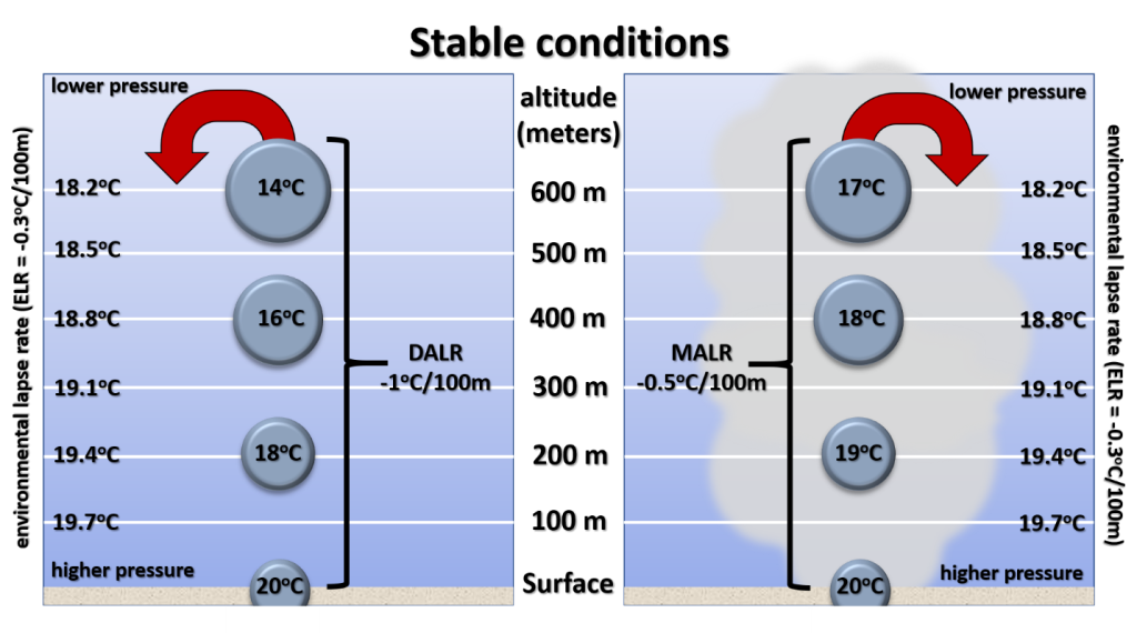
The left side of this diagram is the dry adiabatic lapse rate without condensation. The right side is for a moist environment with condensation. The environmental lapse rate (ELR) in this example is -0.3oC / 100m, which is a warm atmosphere.
The air parcel is cooler at all altitudes as it rises. Colder air parcels are denser and sink. The latent heat associated with condensation causes the parcel on the right side to be warmer than the left, but still cooler than the environment.
Video: Mod 4.5.3 Stable conditions (3:45 min.)
This short video examines stable conditions and relates them to a Stüve diagram.
4.5.4 Conditionally Stable (or Unstable) Conditions
At times, the atmosphere may be stable or unstable. Stable conditions occur if the air parcel once lifted returns to its original position. Unstable conditions occur if the air parcel once lifted continues to rise. This “uncertain” state of the atmosphere is designated as conditionally stable (or conditionally unstable). The determining factor on stability in this situation is whether the latent heat associated with condensation warms the parcel enough for it to continue rising. This diagram illustrates a conditionally stable situation.
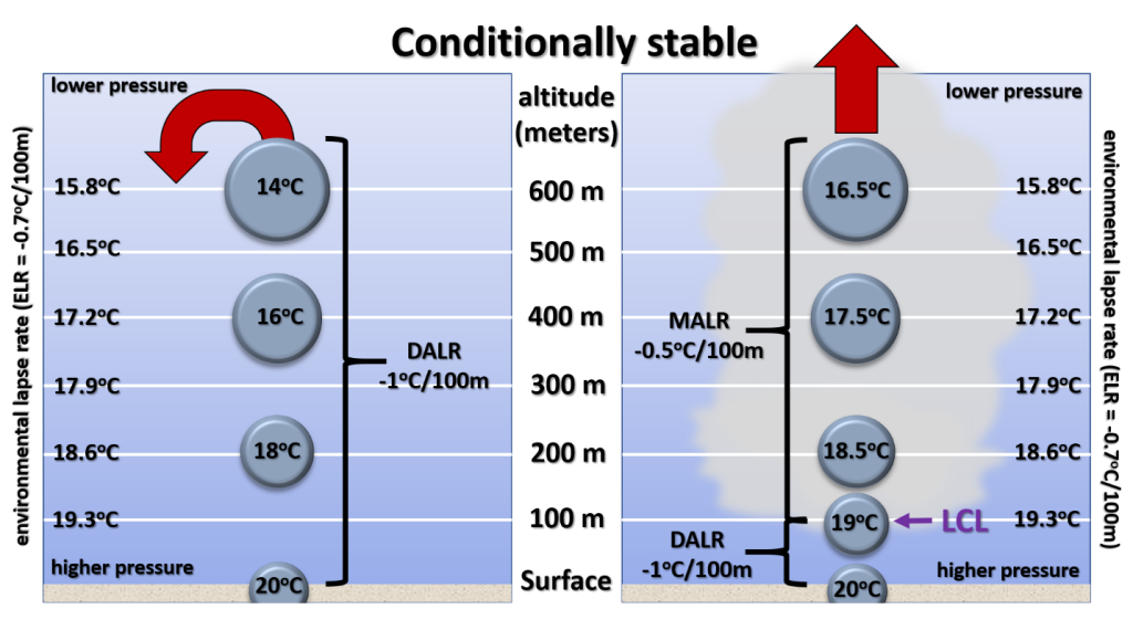
The left side of this diagram is the dry adiabatic lapse rate without condensation. The right side is for a moist environment with condensation. Since air parcels at the surface do not normally have condensation occurring, a Lifting Condensation Level (LCL) has been added on the right to indicate when condensation starts. Before condensation happens the air parcel is lifted according to the dry adiabatic lapse rate. The environmental lapse rate (ELR) in this example is -0.7oC / 100m. Notice the ELR is between the DALR (-1.0oC / 100m) and the MALR (-0.5oC / 100m). On the left side with no condensation, the air parcel is cooler at all altitudes as it rises. These colder air parcels sink. On the right side with condensation occurring, the parcel is cooler than the environment at both the 100 and 200-meter altitudes. Once higher than 200 meters, the parcel becomes warmer than the environment and can continue to rise on its own. The latent heat of condensation has warmed the parcel enough to become unstable.
The difficult factor in determining whether a conditionally stable parcel becomes unstable is whether the lifting mechanism can push the parcel high enough to cause condensation. The height of the Lifting Condensation Level (LCL) is essential in determining stability, and the Stüve diagram can be used to find the LCL.
Video: Mod 4.5.4 Lifting condensation level (2:22 min.)
This short video on finding the LCL is optional but describes the procedure for finding an LCL.
Video: Mod 4.5.4 Conditionally stable (5:12 min.)
This recommended video examines conditionally stable conditions and relates them to a Stüve diagram.
4.5.5 Extremely Stable Air
Extremely Stable Air (Inversions)
Once an air parcel becomes unstable and continues to rise on its own, what stops it? Two common conditions can stop a parcel from rising (1) a dry layer of air aloft and (2) a warmer layer of air aloft.
Unstable conditions are usually a result of condensation occurring and warming the parcel. Theoretically these rising parcels contain air from where they originated. In reality, these parcels are affected by the surrounding atmosphere as they rise. If an air parcel encounters a dry layer, this drier air can halt condensation which results in the parcel becoming cooler than the environment. Thus, a parcel may rise to a certain level on its own, but then sink once it encounters dry air.
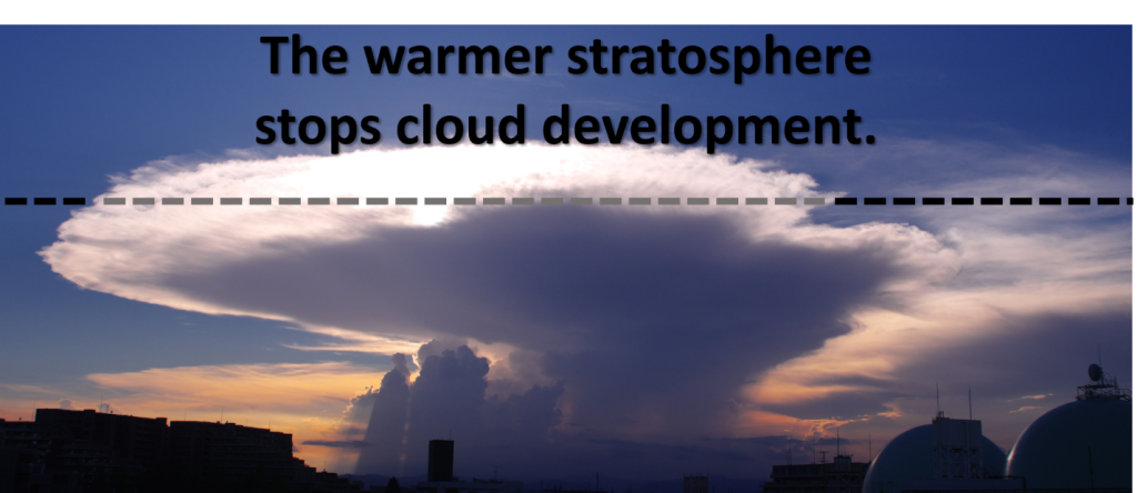
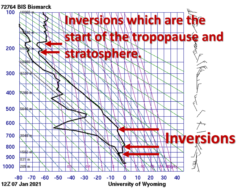
The second condition which halts a rising air parcel is an inversion. Temperatures that increase with height are called an inversion. When an inversion is present, the parcel encounters air that is warmer than itself. Thus, the parcel is suddenly cooler than the environment and starts to sink. Inversions can be detected in a sounding by a kink in the temperature plot. Normally temperatures decrease with height in the troposphere. When an inversion is present this normal decrease in temperature is reversed resulting in a zig or kink in the sounding. The ultimate inversion for the troposphere is the stratosphere. Remember that temperatures increase with height in the stratosphere. Strong thunderstorms push up against the stratosphere and flatten out. Hence, if you have seen a healthy thunderstorm, you have likely seen the location of the stratosphere and the effects of an inversion.
This sounding from Bismarck, North Dakota illustrates multiple inversions.
Watch this Video
This short video clip demonstrates how a rising air parcel reacts when encountering an inversion.
References:
Most material and illustrations in this section are in the public domain and are from NOAA, NWS at https://www.weather.gov/jetstream/bowls
incoming energy details.jpg – From NOAA, NWS public domain at https://www.weather.gov/jetstream/energy
CB with stratosphere line.png – Public domain image from Wikimedia Commons https://commons.wikimedia.org/wiki/File:08-30-2020_Cumululonimbus_cloud.jpg
inversion.mp4 – The COMET Program

